


© Alex KL Hiking - 2012/2013 Member of the Malaysia Nature Guide Association

Sharing our hiking passion with you...


It's always Tabur West or Tabur East which are scheduled for KL Hiking events, so I thought of changing the dish a bit, but keeping the
spices!
I heard some contradicting information about the “other” Tabur. Sometimes it's called “Far East”, “X” or “Extreme” and I'm not sure
whether they all refer to the same venue. Some say it's called “Far East” and “Extreme” because they're out of the way, further than
West and East. And then they add that this Tabur is by far the easiest one. Others proclaim it's called “Extreme” because of its
difficulty rating. So time to find out for myself...
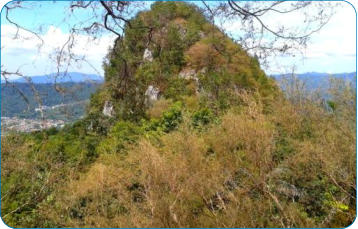
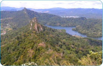
I'm not sure that the Tabur I did is indeed the “Extreme” or “Far East” but fact is that this Tabur, and let me call it Tabur X is higher
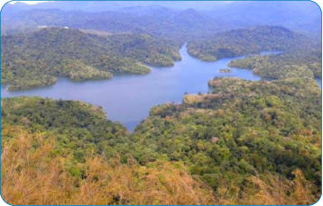
than West and East and offers similar spectacular views on KL and the Klang Gates Lake.
Myth no.1 was debunked quite quickly. Tabur X is not an easy climb, and certainly not for the faint of heart. Looking up in the sky,
following Tabur's contours and silhouette, I arrived in an orang asli settlement from where I must be able to start the climb. Despite
the fact that my knowledge of Bahasa Malaysia is limited to makan and minum, we managed to communicate through Bahasa Jalan
Kaki. Most probably Bahasa Malaysia wouldn't have helped me that much either. A young Iban Sarawakian told me in chopped English
that they speak Bahasa Orang Asli among themselves. Not only the appearance of a white guy in the village is something that only
happens in a blue moon, but now the mat salleh even wanted to climb Tabur... In pure cinematographic style several youngsters
followed my footsteps and without any hesitation from my part, I accepted them as the expedition crew.
We left the village on a narrow path and reached an old logging road. I thought it's gonna be a piece of cake like this but after a few
meters they already pointed to a wall of rocks on the right hand side. Did I really have to go up here? What a start! Once the rock
section behind us, there was no clear trail. It was obvious that those who ever climbed this Tabur before had used a different access
route.
Although the entire distance of the trail is not that long, it has it challenges and the use of hands and legs is more often required than
not. Tabur consists of a series of peaks and this one is no exception. At a certain moment we reached such peak and it looked as if the
journey would come abruptly to an end. The gap in front of us was steep and deep. We had a quick look, but realised that it would be
impossible to to descend that way in our quest to reach the next peak without taking serious risks.
We turned back, but didn't surrender yet. We noticed a clear track further down which was leading all the way down and then almost
80 degrees up again. Strange enough there were ropes in place here, so I assume that I had joined my predecessors trail. After all we
managed to get up all the way and I enjoyed the amazing scenery of nature on my right, the Klang Gates lake embedded in the dense
jungle, and so-called civilisation on my left. When we reached another steep cliff and I could only see another Tabur (Tabur East?) in
the distance, I realised we had reached the terminus.
Just as it is the case with the other Tabur climbs, also here we have a shortcut downhill. We came down through the jungle and orang
asli gardens and reached eventually the settlement once again.
Well, if you have hiked Tabur West and East so many times that you can do it almost blindfolded, here's the chance to add a new
Tabur trail to your hiking schedule. We'll organise it for KL Hiking shortly. Join us and I'm sure you won't regret it...
Tabur X - Survey hike
12-Feb-2012